London crime map goes live
The beta of the Met Police crime map mashup has gone live, and Southwark doesn’t look good.

The Metropolitan Police has launched the first beta version of its nearly London-wide online crime map.
Last month, the Home Office announced that such interactive, street-by-street crime maps would be created for the whole of the UK.
The Met seems to have pipped West Midlands to the post with its release, as the latter force was expected to be the first to go live with such a mapping system in September.
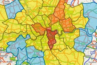
Created with Google Maps, the London beta shows burglary, robbery and vehicle crime rates across the boroughs except for the City of London, which has its own police force by High, Above Average, Average, Below Average and Low. Southwark is the only one to be rated High', while Westminster, Waltham Forest, Hackney and Newham all received Above Average' ratings.
Zoom in or search by post code, and the map breaks down by ward and subwards in each borough, using the same rating system. It also shows monthly crime trends and more detailed comparative statistics by borough and ward, but not by subward - so street-by-street comparisons are not yet possible.
The map uses data to June 2008, and at the moment, only includes burglary, robbery and vehicle crime.
A statement on the map site said the mashup was not complete, and is "intended to test the functionality of crime mapping, with a view to adding further features in the near future, based on your feedback."
Get the ITPro. daily newsletter
Receive our latest news, industry updates, featured resources and more. Sign up today to receive our FREE report on AI cyber crime & security - newly updated for 2024.
There is a form on the site to collect feedback here.


